How we future-proofed a healthcare mapping app by Akros
Akros developed an open-source tool for healthcare mapping in Africa. We optimized it, making it more configurable, scalable, and intuitive.
Akros is a public health organization that works on improving the delivery of health interventions – like vaccine rollouts and malaria prevention programmes – across southern and western Africa. We worked on Reveal, an open-source mapping app that helps field teams to record and analyze health data in any community, no matter how remote.
The challenge: public health mapping in remote areas
Akros had developed a mapping app called Reveal which uses satellite imagery to understand where people live, what services they have access to and plan for health campaigns to ensure all people have adequate access. Working in often remote areas with no formal address system, the app is an essential tool in making sure healthcare reaches as many people as possible. The app has been a key part of their work on malaria and neglected tropical disease elimination in southern, western and eastern Africa, and as a key partner on the COVAX GIS working group, as well as multiple other coalitions.
The app had basic mapping functionality, and Akros requested us to improve it. Our goal: make it faster, more interactive, more configurable by the end user, and easier to use. And in the process, we’d be helping to make high-quality data accessible and useful for decision makers in countries across Africa.
The team: data specialists
We assembled a team of data specialists with experience in mapping apps – people who love to take large, unwieldy sets of data and turn them into something simple, elegant and useful.

Get invaluable business insights. Make core decisions with ease.
We are offering leading end-to-end data solutions that will help you make the best business decisions, improve user experience, and turn your big vision into reality. Your dreams. Our expertise. Together, we give you the strength to succeed.
Learn moreResults: an optimized, automated platform
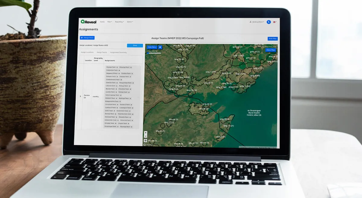
We made the maps much more interactive and intuitive - allowing users to zoom in and out, filter out layers of information, and automatically input data into a central database. Its usefulness extends beyond public health programmes too - Reveal can also be used as a census tool, or to trace water resources.
Our first task was to prepare the data for maps. The Reveal maps have many layers of information - starting with geography, but adding information about population, infrastructure, water reserves and more.
How we got those results:
Importing, storing and accessing data
The majority of data for import was held in spreadsheets, making it difficult to input, slow to access, and unmanageable at scale. We created a central database, and developed ways for data to be automatically input. The result? Data importing originally took a day per country. Now it takes under an hour.
Zoom into the detail
The app originally had a static map image, with information overload. We made it fully interactive, allowing users to zoom in and out, and see exactly the detail they need at any given time - whether it’s local resources, vaccination management or census responses.
Find everything faster
Instead of having to load all the geo data at once for every task, we separated it into smaller fractions - so the app only loads the most relevant data, and loads it a whole lot faster too.
Real-time updates and detailed reports
It’s important for field teams - and government decision makers - to have the most up to date information. As soon as the data have been updated, it displays on the digital maps. And to make data more shareable, we developed a reports function, allowing teams to export the most relevant data and share it with stakeholders outside the app.
The tech we used:
- For the web app – we used ReactJS v17
- For the back end – we used Spring Boot and Java 11
- For the database – we built it with PostgreSQL
- For saving and searching – we used ElasticSearch for the geo- and metadata
- For event store – we used Kafka for different types of events and communication